|
Services,
GHVM has developed a suite of software GeoConstructor that
allows us to efficiently acquire the data and photographs necessary
to construct large scale, high optical resolution models. Models
that contain >20 million triangles and >800 photographs (24.5 Mpx)
have been assembled for kilometer scale geological outcrops. The
models were acquired using high speed terrestrial LiDAR at a range
of 60 to 500m and a robotic camera system with a 300mm lens. The
optical resolution of the models was 1.5 mm/pixel in the areas of
interest.
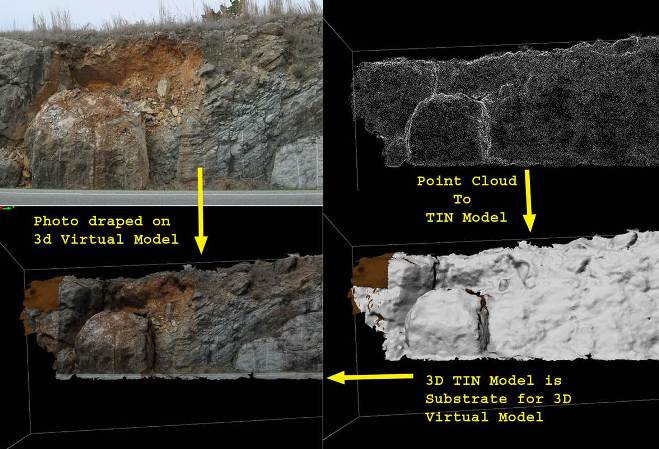
In order to create a photorealistic model of a geological outcrop,
or man-made structure, the surface of the outcrop is captured using
high speed terrestrial LiDAR scanners. The point cloud image of the
outcrop is converted into a TIN mesh surface. Photographs are then
draped onto the mesh to create a photorealistic model of the
outcrop. The draping is accomplished by mapping each vertex in the
mesh to its appropriate point in a photograph. The mapping process
requires that each photograph be oriented to the model in exactly
the same orientation as the camera to the outcrop at the time that
the photograph was taken. The orientation step requires at least
four tie-points between the photograph and the model. Usually, this
is done manually resulting in one or two photographs being processed
per hour and often with poor accuracy. In order to efficiently
drape a large number of photographs onto a large scale TIN mesh, it
is necessary to dramatically increase the speed with which the
photograph-to-model tie-points are identified. Our
GeoConstructor software combines a robotic total station, a
robotic pan-tilt stage, and a large format (24.5 Mpx) professional
DSLR camera with telescopic lenses to create an automated system for
outcrop photograph acquisition and photograph tie-point
registration.
The GeoConstructor software controls the assembly of the
photorealistic model using the TIN mesh of the outcrop and the
auto-generated tie-points for the photographs. The software
includes quality improvement algorithms to prevent the draping of
occluded surfaces, minimize grazing angle smearing, and the masking
of unwanted features in the photographs. |
|